Petrópolis and the Challenge of Climate Change
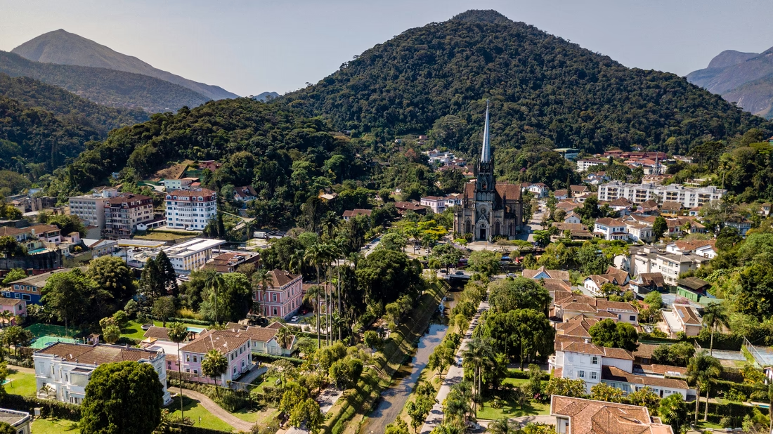
Petrópolis is a Brazilian city set in the Serra dos Órgãos mountains, known for its rich history, architectural heritage, and stunning mountainous landscapes, which, despite its charm, faces an ever-present climate threat that is pushing it toward an increasingly fragile future.
Historical and Environmental Context
Petrópolis mountainous terrain naturally makes the city prone to landslides, flooding and river overflows, creating unique environmental challenges that expose residents to recurring disasters. The slopes dominate the landscape, leaving limited flat land for development.
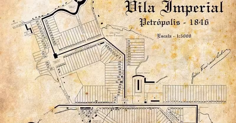
It was originally designed in 1843 as one of Brazil’s first planned city by civil engineer Julius Friedrich Koeler, intended as a summer retreat for Emperor Dom Pedro II. Koeler’s plans took into account the local climate and terrain risks, with sustainable designs aimed at preserving the city’s stability and resilience.
For example, there were instructions for establishing reserves, high up in mountains and hills, of the forests necessary for water conservation, aiming to avoid the depletion of water resources as well as landslides. To build Petrópolis, Koeler carried out a detailed topographic survey for more than a year.
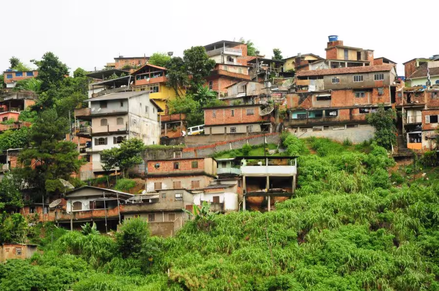
However, the original planning wasn’t fully adhered to, and subsequent alterations in the infrastructure and landscape increased the city’s susceptibility to natural disasters over time. As the time passed and the population grew, more and more homes and buildings have been constructed on hillsides, often without professional oversight from engineers or architects.
These structures can further destabilize the soil, making landslides more likely—especially during the heavy rains common to the area. Additionally, much of this construction takes place in environmental protection zones or on steep slopes, where deforestation to make room for new homes and buildings has further compromised soil stability, heightening the risk of landslides and floods across the city.
Community Awareness and Preparedness
Petrópolis faces regular climate risks, but community preparation and awareness remain limited. While the civil defense agency has created guides with emergency plans, lists for evacuation strategies, and emergency kits, these resources are not widely shared by the city’s administration.
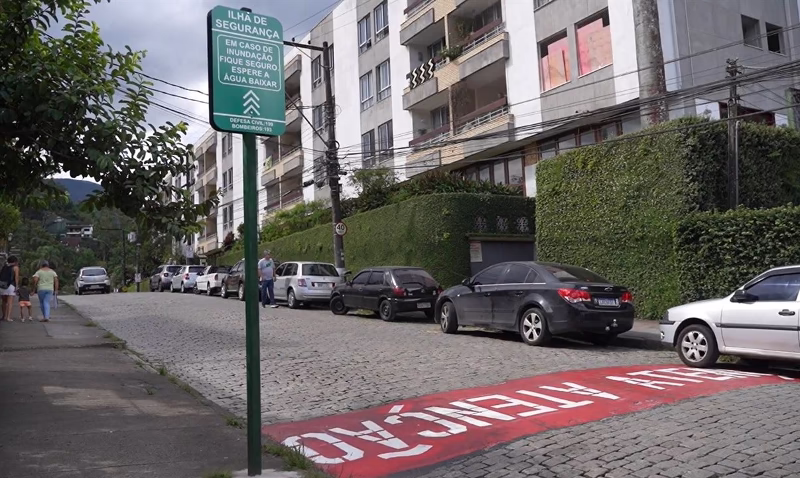
Efforts to inform the public about these safety measures are minimal, and the resources that are shared mainly cover flood monitoring along Rua Coronel Veiga, one of the city’s main access roads, and the “safety islands”—designated flood-safe points in the central city area. You can find an interactive map of the Safety Islands’ locations by clicking the button below.
For intense rainfall events, sirens are set up to sound alerts, advising people to move to designated shelters, often located in schools or churches. However, during heavy rains, the sound of the rain itself often drowns out these sirens, leaving residents without clear warnings.
For homes located on hillsides, where landslide risk is high, there are no proactive safety measures in place to reduce risk. Consequently, many residents remain vulnerable during storm events, and greater visibility of these emergency plans and resources is essential for public safety.
The city government has prepared a Municipal Risk Reduction Plan (PMRR) that lists 234 locations considered to be at high or very high risk for landslides, floods and river overflows. The critical area is equivalent to 18% of the territory, and the plan is the first in the city’s history to encompass all five districts. Although the plan is from 2017 and is outdated, you can access it clicking the button below.
The Civil Defense also prepared contingency plans to deal with emergencies and disasters caused by hydrological phenomena (floods, inundations and downpours), geological phenomena (mass movements) and meteorological phenomena (storms, hail, strong winds and heavy rains).
Impact of Climate Patterns
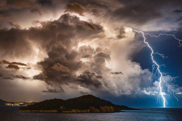
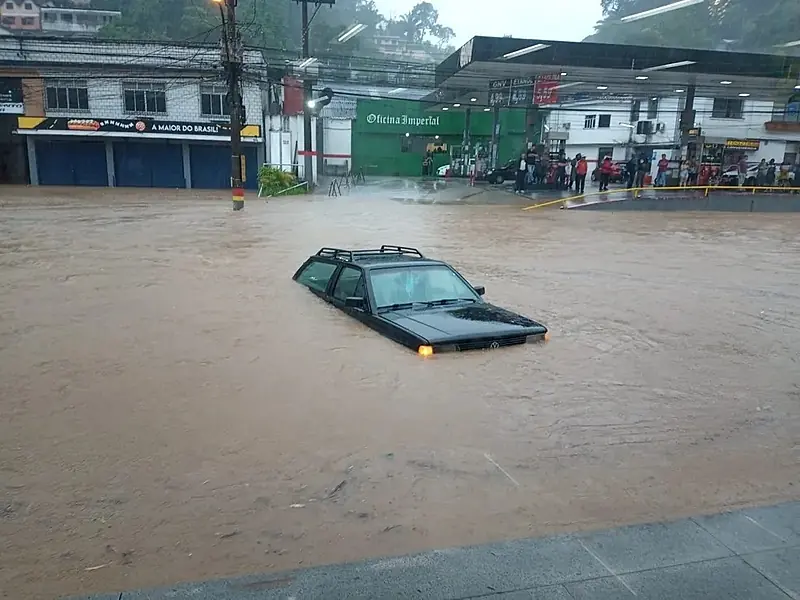
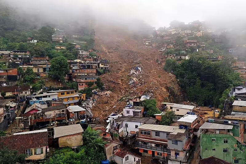
In February 2022, severe rains led to devastating landslides, flooding, and river overflows that destroyed homes, blocked roads, and caused tragic loss of life. The rain accumulation rate in 24 hours was a Brazilian record at the time (534,4 mm/day), and today it ranks as the third highest precipitation rate in 24 hours in the country’s history.
In recent years, Petrópolis has faced more frequent and intense weather events, especially worsened by global warming, and also by the South Atlantic convergence zone (ZCAS in Portuguese) system, cold fronts and climate patterns like La Niña.
During La Niña, there is a facilitation of cold fronts entering the region, which often experiences heavier-than-normal rainfall and can quickly overwhelm the city’s steep terrain. This pattern is a reminder of how vulnerable Petrópolis is to climate shifts. With a weak to moderate La Niña expected this coming summer, residents remain on high alert, especially those living in areas previously hit by previous incidents. You can find our article about the connection between El Niño / La Niña and natural disasters here.
Lack of Preventive Infrastructure and Oversight
Only a few infrastructure projects have been completed in Petrópolis to help manage landslides, flooding, and river overflows, while many planned projects remain unfinished. Unfortunately, even the projects currently being discussed are far from enough to make the city significantly safer.
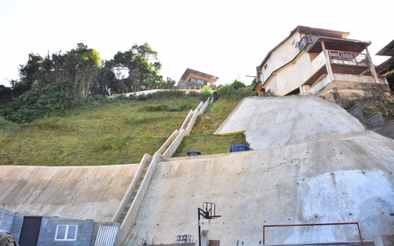
Efforts to control construction in Petrópolis have often been inadequate and virtually absent, allowing development in high-risk zones without robust inspection. This issue has led to a landscape filled with unplanned constructions, which, in many cases, further destabilize the soil and amplify the risk of landslides. Without better drainage systems, retaining walls, and flood barriers, the city remains highly exposed to the impacts of heavy rains and river overflows.
Innovative Solutions for Mitigation and Adaptation
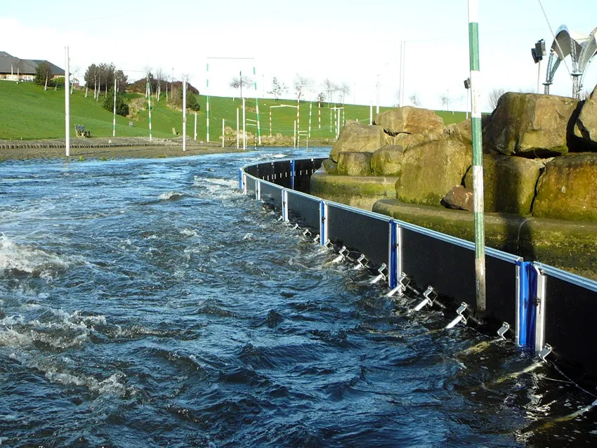
To protect Petrópolis from landslides, flooding, and river overflows, there are several innovative solutions that could be helpful. Cities around the world use advanced technologies to manage flood and landslide risks, and some of these could be adapted for Petrópolis. For example, flood barriers like the Neo-Barrier™ system, which is made of reinforced thermoplastic composite panels, or portable inflatable dams can be deployed quickly to hold back water during heavy rains. These types of barriers could help prevent flooding in areas close to rivers and lower-lying streets, reducing damage in central parts of the city.
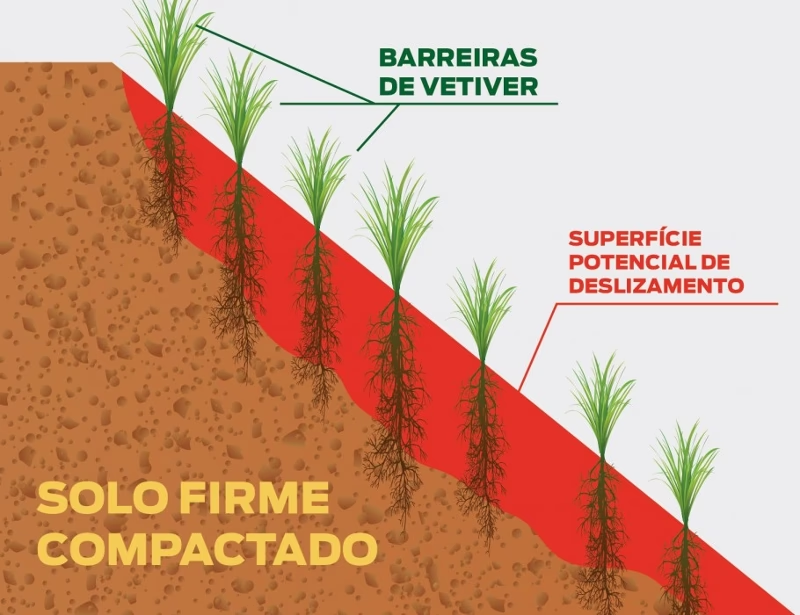
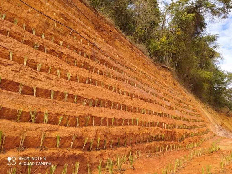
Another effective solution is using vetiver grass on hillsides. Vetiver has strong, deep roots that help stabilize the soil, making it harder for landslides to occur. This method could be valuable for areas with unplanned housing on slopes, where landslides are more likely due to deforestation and unregulated building. Vetiver planting is a low-cost, sustainable option that could be part of a broader strategy to make slopes more secure.
Petrópolis could also benefit from green infrastructure projects, like rainwater detention basins, or “piscinões,” which are large underground tanks or open basins that collect rainwater and slowly release it to avoid overwhelming drainage systems. These basins are especially effective in flatter, flood-prone areas. By capturing and controlling rainwater, they help reduce the risk of flash floods during storms.
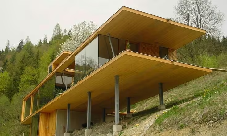
Finally, using lightweight and flexible building materials such as cross-laminated timber (CLT), which offers good tensile and compressive strength for hillside homes would improve housing stability in case of soil movement. The use of materials with these properties, along with safe construction practices, would make homes better prepared to handle the region’s natural risks. Combining these solutions with better planning and regular inspections could help Petrópolis build a more resilient and safer future.
Building a Safer Future for Petrópolis
Petrópolis’ unique geography and unpredictable weather require a proactive approach to reduce future risks and enhance community resilience. Ensuring safe construction, particularly on hillsides and near rivers, is critical. Following stricter building codes with professional oversight from architects and engineers can greatly improve the stability and safety of both new and existing structures. Additionally, authorities could conduct regular inspections to prevent unauthorized, high-risk construction.
Upgrading drainage systems, installing retaining walls, and expanding flood barriers where necessary would also reinforce the city’s infrastructure. Green infrastructure, such as rainwater basins, can further reduce flood risks in vulnerable areas. Expanding “safety islands” beyond the city center would create more accessible refuges for residents during heavy rains, and well-maintained emergency shelters would enhance overall preparedness.
On the community side, clear, accessible information about evacuation routes and emergency plans is vital. Awareness campaigns and practical guidance on creating emergency kits and safe evacuation could save lives. Through collaboration, authorities, engineers, and residents can work toward shared safety goals, making Petrópolis a model of climate resilience.
Combining these efforts with sustainable construction practices and smart planning will strengthen Petrópolis against future challenges. With a cohesive approach that integrates advanced technology, green solutions, and stricter building inspections, Petrópolis can become a city resilient in the face of climate change. By embracing these strategies, the community can thrive even amidst the growing risks of a world suffering from global warming and climate changes.